Kamchatka Peninsula
.svg.png)
The Kamchatka Peninsula (Russian: полуо́стров Камча́тка, poluostrov Kamchatka) is a 1,250-kilometer long peninsula in the Russian Far East, with an area of 472,300 km2 (182,400 sq mi). It lies between the Pacific Ocean to the east and the Sea of Okhotsk to the west.[1] Immediately offshore along the Pacific coast of the peninsula runs the 10,500-metre (34,400 ft) deep Kuril-Kamchatka Trench.
The Kamchatka Peninsula, the Commander Islands, and Karaginsky Island constitute the Kamchatka Krai of the Russian Federation. The majority of the 402,500 inhabitants are Russians, but there are also about 13,000 Koryaks. More than half of the population lives in Petropavlovsk-Kamchatsky (198,028 people) and nearby Yelizovo (41,533).
The Kamchatka peninsula contains the Volcanoes of Kamchatka, a UNESCO World Heritage Site.
Kamchatka receives up to 2,700 mm (110 in) of precipitation per year. The summers are moderately cool, and the winters tend to be rather stormy with rare amounts of lightning.
Contents |
Geography

|
|
It is requested that a diagram or diagrams be included in this article to improve its quality. For more information, refer to discussion on this page and/or the listing at Wikipedia:Requested images. |
Politically, the peninsula is part of Kamchatka Krai. The southern tip is called Cape Lopatka. The circular bay to the north of this on the Pacific side is Avacha Bay with the capital, Petropavlovsk-Kamchatsky. North up the Pacific side, the four peninsulas are called Shipunsky Point, Kronotsky Point, Kamchatsky Point and Ozernoy Point. North of Ozernoy is the large Karaginsky Bay and island. Northeast of this off the map is Korfa Bay with the town of Tilichiki. On the opposite side is the Shelikhov Gulf.
The spine of the peninsula is the Kamchatka or Central Range. Along the southeast coast is the Vostochny or Eastern Range. Between these is the central valley. The Kamchatka River starts northwest of Avacha and flows north down the central valley, turning east near Klyuchi to enter the Pacific south of Kamchatsky Point at Ust-Kamchatsk. In the nineteenth century a trail led west from near Klychi over the mountains to Tegil river and town which was the main trading post on the west coast. North of Tegil is Koryak okrug. South of the Tegil is the Icha River. Just south of the headwaters of the Kamchatka, the Bistraya River curves southwest to enter the Sea of Okhotsk at Bolsheretsk, which was once a port connecting the peninsula to Okhotsk. South of the Bistraya is the Golygina River.
There is a road from Bolsheretsk to Petropavlovsk and another from this road up the central valley (with a bus service) to Ust-Kamchatsk. The northern end of the road is of poorer quality. Apart from the two roads, transport is by small plane, helicopter, four-wheel drive truck and army truck.
The obvious circular area in the central valley is the Klyuchevskaya Sopka, an isolated volcanic group southeast of the curve of the Kamchatka River. West of Kronotsky Point is the Kronotsky Biosphere Reserve with the Valley of Geysers. At the southern tip is the Southern Kamchatka Wildlife Refuge with Kurile Lake. There are several other protected areas: Palana is located in the Koryak area on the northwest coast.
|
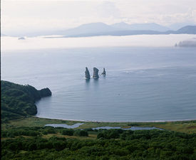
Topography of the Kamchatka Peninsula. |
 The Kamchatka Peninsula as seen from space. |
Sea ice imitates the shoreline along the peninsula. |
History and exploration
.jpg)
When the Russians reached the Sea of Okhotsk (Ivan Moskvitin, 1638) they were blocked because they lacked the skills and equipment to build sea-going ships. The country to the northeast was difficult and the Koryaks warlike. Therefore, Kamchatka was entered from the north. After helping found Anadyrsk, in 1651 Mikhail Stadukhin went south and followed the coast of the Sea of Okhotsk from Penzhina Bay to Okhotsk. From about 1667 there were reports of a Kamchatka River to the south. Some time before 1700 a group of Russians were stranded and died on Kamchatka.
In 1695 Vladimir Atlasov was made prikashchik of Anadyrsk. In 1696 he sent Luka Morozko south. Morozko got as far as the Tigil River and returned with reports and some mysterious writings, probably Japanese. In 1697-1699 Atlasov explored nearly the whole of the peninsula. He built an ostrog at Verkhny-Kamchatsk and rescued or captured a Japanese castaway and went to Moscow to report. In 1699 the Russians at Verkhny-Kamchatsk were killed by the Koryaks on their way back to Anadyrsk. The 1700 punitive expedition destroyed a Koryak village and founded Nizhne-Kamchatsk on the lower river. Bolskeretsk was founded in 1703. From about 1705 there was a breakdown of order. There were numerous mutinies and native wars all over the peninsula and north to the Koryak country of the Penzhina River and Olyutorsky Gulf. Several people were sent out to restore order, including Atlasov who was murdered in 1711. Some degree of order was restored by Vasily Merlin in 1733-39. There was no significant resistance after 1756. A major smallpox epidemic hit in 1768-69. By 1773 there were about 2,500 Itelmen and in 1820 1,900, down from an original population of 12 to 25 thousand. Russian customs were adopted and there was a great deal of intermarriage so that Kamchadal, the original Russian name for the Itelmen, came to mean any Russian or part-Russian born on the peninsula.
In 1713 Peter the Great sent shipbuilders to Okhotsk. A fifty-four-foot boat was built and sailed to the Tegil River (June,1716). This one week journey, later shifted to Okhotsk-Bolseretsk, became the standard route to Kamchatka. Vitus Bering's first voyage left Nezhe-Kamchatsk in 1728. As part of his second voyage he founded Petropavlovsk-Kamchatsky in 1740.
The Second Kamchatka Expedition by the Danish explorer Vitus Bering, in the employ of the Russian Navy, began the "opening" of Kamchatka in earnest, helped by the fact that the government began to use the area as a place of exile. In 1755, Stepan Krasheninnikov published the first detailed description of the peninsula, An Account of the Land of Kamchatka. The Russian government encouraged the commercial activities of the Russian-American Company by granting land to newcomers on the peninsula. By 1812, the indigenous population had fallen to fewer than 3,200, while the Russian population had risen to 2,500.
In 1854, the French and British, who were battling Russian forces on the Crimean Peninsula, attacked Petropavlovsk-Kamchatsky. During the Siege of Petropavlovsk, 988 men with a mere 68 guns managed to defend the outpost against 6 ships with 206 guns and 2,540 French and British soldiers. Despite the heroic defence, Petropavlovsk was abandoned as a strategic liability after the Anglo-French forces withdrew. The next year when a second enemy force came to attack the port, they found it deserted. Frustrated, the ships bombarded the city and withdrew.
The next fifty years were lean ones for Kamchatka. The naval port was moved to Ust-Amur and in 1867 Alaska was sold to the United States, making Petropavlovsk obsolete as a transit point for traders and explorers on their way to the American territories. In 1860, Primorsky (Maritime) Region was established and Kamchatka was placed under its jurisdiction. In 1875, the Kuril Islands were ceded to Japan in return for Russian sovereignty over Sakhalin. The Russian population of Kamchatka stayed around 2,500 until the turn of the century, while the native population increased to 5,000.
World War II hardly affected Kamchatka except for its service as a launch site for the invasion of the Kurils in late 1945. After the war, Kamchatka was declared a military zone. Kamchatka remained closed to Russians until 1989 and to foreigners until 1990.
Volcanoes
| Volcanoes of Kamchatka* | |
|---|---|
| UNESCO World Heritage Site | |
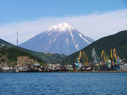
Koryaksky Volcano rising above Petropavlovsk-Kamchatskiy.
|
|
| Type | Natural |
| Criteria | vii, viii, ix, x |
| Reference | 765 |
| Region** | Asia |
| Inscription history | |
| Inscription | 1996 (20th Session) |
| Extensions | 2001 |
| * Name as inscribed on World Heritage List. ** Region as classified by UNESCO. |
|
List of volcanoes in Russia has a list of most Kamchatka volcanoes with links.
The Kamchatka River and the surrounding central side valley are flanked by large volcanic belts containing around 160 volcanoes, 29 of them still active. The peninsula has a high density of volcanoes and associated volcanic phenomena, with 19 active volcanoes being included in the six UNESCO World Heritage List sites in the Volcanoes of Kamchatka group, most of them on the Kamchatka Peninsula.[2]
The highest volcano is Klyuchevskaya Sopka (4,750 m or 15,584 ft), the largest active volcano in the Northern Hemisphere [3], while the most striking is Kronotsky, whose perfect cone was said by celebrated volcanologists Robert and Barbara Decker to be a prime candidate for the world's most beautiful volcano. Somewhat more accessible are the three volcanoes visible from Petropavlovsk-Kamchatsky: Koryaksky, Avachinsky, and Kozelsky. In the center of Kamchatka is Eurasia's world famous Geyser Valley which was partly destroyed by a massive mudslide in June 2007.[4]
Owing to the Kuril-Kamchatka Trench, deep-focus seismic events and tsunamis are fairly common. A pair of megathrust earthquakes occurred off the coast on October 16, 1737, and on November 4, 1952, in the magnitude of ~9.3 and 8.2 respectively.[5] A chain of more shallow earthquakes were recorded as recently as April 2006.[6]
Terrestrial flora
Kamchatka boasts abundant flora. The variable climate promotes different flora zones where tundra and muskeg are dominant succeeded by grasses, flowering shrubs and forests of pine, birch, alder and willow. The wide variety of plant forms spread throughout the Peninsula promotes just as wide a variation in animal species that feed off them. Although precipitation in Kamchatka is high, along with milder winters and fertile soil, surprisingly, forests do not stretch as wide as in the rest of Siberia, since the location near the coast lowers summer temperatures, whereas in Siberia, the much warmer summers allow ample sunlight for forests. Instead, the vegetation is mostly tundra, with a few scattered forests in and around the interior.
Terrestrial and aquatic fauna
Kamchatka boasts diverse and abundant wildlife. This is due to climates ranging from temperate to subarctic, diverse topography and geography, many free-flowing rivers, proximity to highly productive waters from the northwestern Pacific Ocean and the Bering and Okhotsk Seas, and to the low human density and minimal development. It also boasts the southernmost expanse of Arctic tundra in the world. Commercial exploitation of marine resources and a history of fur trapping has taken its toll on several species.
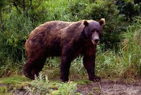
Among terrestrial mammals, Kamchatka is best known for the abundance and size of its brown bears. In the Kronotsky Nature Preserve there are estimated to be three to four bears per 100 square kilometres.[7] Other fauna of note include carnivores such as wolf, arctic and other fox, lynx, wolverine, sable, several species of weasel, ermine and river otter; several large ungulates, such as bighorn sheep, reindeer, and moose; and rodents/leporids, including hares, marmot, lemming and several species of squirrel. The peninsula is the breeding ground for Steller's sea eagle,[8] one of the largest eagle species, along with the golden eagle and gyr falcon.
Kamchatka contains probably the world's greatest diversity of salmonid fish, including all six species of anadromous Pacific salmon (chinook, chum, coho, seema, pink, and sockeye). Biologists estimate that a sixth to a quarter of all Pacific salmon originates in Kamchatka. [1] Kuril Lake is recognized as the biggest spawning-ground for sockeye in Eurasia. In response to pressure from poaching and to worldwide decreases in salmon stocks, some 24,000 square kilometers (9,300 sq mi) along nine of the more productive salmon rivers are in the process of being set aside as a nature preserve. Stickleback species, particularly Gasterosteus aculeatus and Pungitius pungitius, also occur in many coastal drainages, and are likely present in freshwater as well.
Cetaceans that frequent the highly productive waters of the northwestern Pacific and the Okhotsk Sea include: orcas, Dall's and harbor porpoises, humpback whales, sperm whales and fin whales. Less frequently, grey whales (from the Eastern population), the critically endangered North Pacific Right Whale and Bowhead Whale, beaked whales and minke whales are encountered. Blue whale are known to feed off of the southeastern shelf in summer. Among pinnipeds, Steller's sea lions, northern fur seals, spotted seals and harbor seals are abundant along much of the peninsula. Further north, walruses and bearded seals can be encountered on the Pacific side, and ribbon seals reproduce on the ice of Karaginsky Bay. Sea otters are concentrated primarily on the southern end of the peninsula.
Seabirds include northern fulmars, thick and thin-billed murres, kittiwakes, tufted and horned puffins, red-faced, pelagic and other cormorants, and many other species. Typical of the northern seas, the marine fauna is likewise rich. Of commercial importance are Kamchatka crab (king crab), scallop, squid, pollock, cod, herring, halibut and several species of flatfish.
See also
- Korean Air Lines Flight 007
- Maritime Fur Trade
References
- ↑ "Kamchatka Peninsula". Encyclopedia Britannica. http://www.britannica.com/eb/article-9044464/Kamchatka-Peninsula. Retrieved 2008-02-20.
- ↑ World Heritage (1996). "Volcanoes of Kamchatka". UNESCO. http://whc.unesco.org/en/list/765. Retrieved 2008-02-20.
- ↑ Press Releases - Public Affairs Office - The University of Nottingham
- ↑ The World Wildlife Fund (2007). "Natural Wonder of the World Transformed within Hours, says World Wildlife Fund". earthtimes.org. http://www.earthtimes.org/articles/show/news_press_release,116385.shtml. Retrieved 2008-02-20.
- ↑ "The 4 November 1952 Kamchatka Earthquake and Tsunami". Australian Government Bureau of Meterology. http://www.bom.gov.au/info/tsunami/nov_1952.shtml. Retrieved 2008-02-20.
- ↑ Earthquake Hazards Program (2006). "Magnitude 7.6 - Koryakia, Russia". US Geological Survey. http://earthquake.usgs.gov/eqcenter/eqinthenews/2006/usltbt/. Retrieved 2008-02-20.
- ↑ "Кроноцкий государственный биосферный заповедник, Долина Гейзеров. Туры по Камчатке с камчатской туристической компанией". www.kamchatkatravel.net. http://www.kamchatkatravel.net/rus/kronock.shtml. Retrieved 2008-07-14.
- ↑ "Haliaeetus pelagicus - Detailed documentation". The World Conservation Union Red List. http://www.iucnredlist.org/search/details.php/9650/all. Retrieved 2008-02-20.
Further reading
- Gleadhill, Diana (2007), Kamchatka: A Journal & Guide to Russia's Land of Ice and Fire, Hong Kong: Odyssey Books, ISBN 9789622177802.
External links
- (Russian) Commander Islands
- (Russian) Photos of Kamchatka
- "A Tale of Two Airplanes" by Kingdon R. "King" Hawes, Lt Col, USAF (Ret.)
- Kamchatka – Land of Fire and Ice: Light & Shadow documentary film
- Nechayev picture gallery
- Valley Of geysers, Kamchatka